 HR-CRO - Croatia


 | Pag Island - Old Town Pag |
 | Pag Island - Pag Bridge |
 | Pag Island - Pag |
 | Pag Island - Novalja |
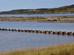 | Pag Island - Pag Salt Pans |
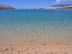 | Pag - Town Beach |
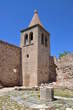
 | Pag - Church of St Mary |


| Pag Island - Old Town Pag |
| Pag Island - Pag Bridge |
| Pag Island - Pag |
| Pag Island - Novalja |
| Pag Island - Pag Salt Pans |
| Pag - Town Beach |
| Pag - Church of St Mary |
Photo: 31060000-0
Photo: 31060000-1
Photo: 31060000-2
Photo: 31060000-3
Photo: 31060000-4
Photo: 31060000-5
Photo: 31060000-6
Photo: 31060000-7
Photo: 31060000-8
Photo: 31060000-9
Photo: 31060000-10
Photo: 31060000-11
Photo: 31060000-12
Photo: 31060000-13
Photo: 31060000-14
Photo: 31060000-15
Photo: 31060000-16
Photo: 31060000-17
Photo: 31060000-18
Photo: 31060000-19
Photo: 31060000-20
Photo: 31060000-21
Photo: 31060000-22
Photo: 31060000-23
Photo: 31060000-24
Photo: 31060000-25
Photo: 31060000-26
Photo: 31060000-27
Photo: 31060000-28
Photo: 31060000-29


